A
B
C
D
लिखित उत्तर
Verified by Experts
The correct Answer is:


Recommended Questions
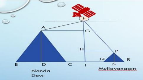
- A Satellite flying at height h is watching the top of the two tallest ...
Text Solution
|
- The angles of depression of two points from the top of the tower are 3...
Text Solution
|
- Where is the Nanda Devi peak located ?
Text Solution
|
- From the top of a mountain of 200 meters height the angles of depressi...
Text Solution
|
- पृथ्वी तल से लगभग 36,000 किमी. ऊपर स्थित उपग्रह भू स्थिर उपग्रह होता ह...
Text Solution
|
- एक व्यक्ति जो किसी पहाड़ की चोटी पर खड़ा है यह देखता है की 1 किमी की दुर...
Text Solution
|
- एक पहाड़ी की चोटी से एक भवन जिसकी ऊँचाई 16 मीटर है, के शिखर तथा आधार क...
Text Solution
|
- The angles of depression of two points from the top of a tower are 30^...
Text Solution
|
- A Satellite flying at height h is watching the top of the two tallest ...
Text Solution
|